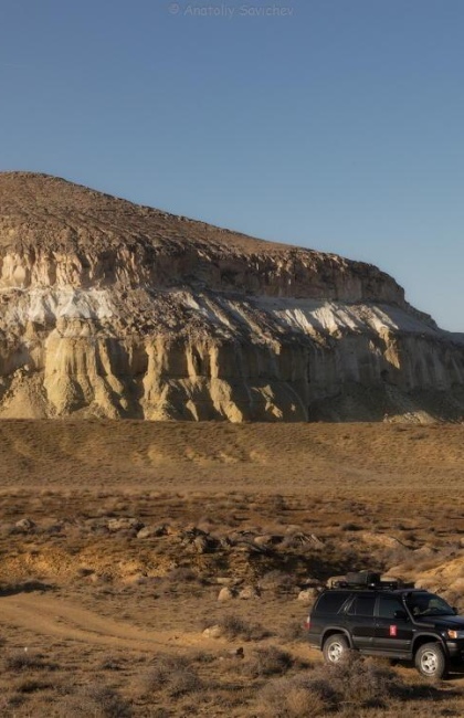
Mount Sherkala
Sherkala is a stand-alone mountain in the Mangystau Region, between the central and western Karatau Mountains. If you look at it from different sides, the mountain’s shape resembles a lion, a piala (a small ceramic bowl), or a yurt (Kazakh national dwelling; a portable, round tent).
Mount Sherkala stands at 322 meters (1056 ft) and has sheer edges. The mountain is composed of clay, chalk, limestone, and sandstone. The southern and eastern sides are very steep, while the northern one is more eroded and gently sloping.
Mount Sherkala stands on one of the routes of the Silk Road, an ancient trade route that once ran between East and West. Judging by historical documents, caravans from Baghdad to the city of Bulgar on the Kama River stopped there. One of the most developed settlements along this leg of the Silk Road was Kyzylkala founded in 1138. Over time, the Silk Road lost its former significance, as the sea route was discovered by Vasco de Gama. Kyzylkala declined and eventually was abandoned.
Mount Sherkala was sung by poets and inspired artists. It can be seen in the drawings of Taras Shevchenko, a Ukrainian artist who was in exile in Mangystau. Bronislaw Zaleski, a Polish political activist and a writer, compared the mountain to the Roman pantheons, and drew a picture called “The Life of the Kazakh Steppes”.
What else to see nearby?
At the foot of the mountain, lies the Torysh Valley, which is also called the Valley of Globular Stones. It got its name for a reason: the valley is strewn with perfectly round boulders, some of which reach the size of 4 meters (13 ft) in diameter.
Also, not far from the mountain, an ancient cemetery has been uncovered. Its tombstones are engraved with petroglyphs of different eras.
The ancient city of Kyzylkala is located just 4 km (2.5 mi) away from the mountain. There, you can see remains of fortifications, a caravanserai (a roadside inn), a mausoleum, and other buildings.
Also be sure to visit the green oasis – Akmysh Grove – and have a rest in the shade of trees, so rare in Mangystau. The oasis is just a few kilometers to the southwest of the mountain.

Important information
To explore the area thoroughly, you will have to walk a lot so wear comfortable shoes. Do not attempt to climb the mountain without rock climbing equipment. Even if you have the equipment and are an experienced climber, ascending Mount Sherkala may still be treacherous. Its heavily weathered limestone slopes are very steep and break easily.
There are also many caves inside Mount Sherkala. Some of them can be easily explored, but others are inaccessible. Keep in mind that the caves may be very dangerous.
How to get there?
The mountain is located 170 km (106 mi) to the northeast of the city of Aktau. The nearest settlement is Shetpe, 18 km (11 mi) away.
Please note that traveling to such remote locations can pose certain risks. Many roads are unpaved so an SUV is a must. To make your trip safe and full of unforgettable emotions, we recommend that you use the services of travel agencies. A tour will also take you to some must-visit destinations nearby.

_420x650_4ab.jpg)
-1_420x650_4ab.jpg)
_420x650_4ab.jpg)
